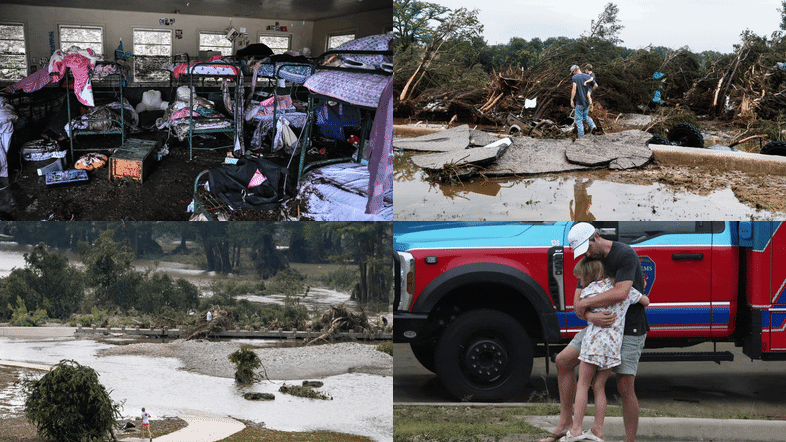
A devastating flash flood on July 4, 2025, struck Nancy Callery’s childhood home in Hunt, Texas, prompting urgent questions about the effectiveness of the U.S. Federal Emergency Management Agency’s (FEMA) flood maps. These maps, established to help identify flood risks, have come under scrutiny as communities grapple with increasingly severe weather and unrecognized vulnerabilities.
FEMA’s flood maps, known as Flood Insurance Rate Maps (FIRMs), serve as a crucial tool for determining flood risk across the United States. Designed in the 1970s to support the National Flood Insurance Program, these maps guide local building codes, land-use decisions, and floodplain management strategies. For instance, areas in Kerrville, Texas, along the Guadalupe River, are depicted with various flood risk levels, yet the recent flash flood revealed alarming discrepancies in risk assessment.
Despite advancements in data and community engagement, FEMA’s flood maps have significant limitations. They primarily focus on river channels and coastal flooding, largely overlooking the risks associated with flash floods. As climate change intensifies, leading to more frequent extreme downpours, many regions remain unaccounted for on these maps, leaving homeowners vulnerable.
Research conducted by First Street, an organization dedicated to quantifying climate risk, indicates that over twice the number of properties face a 100-year flood risk compared to what FEMA’s maps suggest. Areas that have experienced flooding, such as those near Asheville, North Carolina, during Hurricane Helene in 2024, have illustrated the dire consequences of relying solely on FEMA’s assessments.
The inadequacies of FEMA’s mapping process can also be attributed to its reliance on historical data and external political influences. Local governments and developers often lobby to avoid high-risk designations, which can lead to maps that do not accurately reflect the flood risk to residents. A notable example is New York City, which has been operating with outdated flood maps from approximately 20 years ago due to ongoing appeals against FEMA’s updates.
It typically takes between five to seven years to create and implement new FIRMs, resulting in many maps being outdated and failing to account for current land use or urban development. This delay can severely impact building codes and infrastructure planning, as local authorities depend on these maps for construction standards and flood mitigation projects. Inaccurate maps can lead to the construction of vulnerable structures in high-risk areas.
Advancements in technology, such as satellite imaging and high-resolution lidar, present opportunities for more accurate flood risk mapping. However, achieving this requires substantial federal investment and political will. Congress, which controls FEMA’s mapping budget, has historically overlooked the importance of updating flood maps, as changes can lead to stricter building codes and increased insurance costs.
In recent years, private flood risk data and climate risk analytics have emerged as alternatives to FEMA’s maps, allowing sectors such as real estate and finance to assess risks more accurately. Platforms like Zillow and Redfin now offer property-level flood risk scores that take into account both historical data and future climate projections, revealing vulnerabilities that FEMA maps may miss.
As homebuyers become more informed about flood risks, shifting perceptions may affect property values and community assessments over time. Although the new data-driven insights may seem recent, the inherent risks have long existed. The shift lies in the growing awareness of these dangers.
The federal government plays a critical role in ensuring that accurate risk assessments are accessible to communities across the nation. As new tools and models for flood risk assessment evolve, it is essential for FEMA to adapt its mapping practices to reflect these advancements.


