


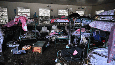


Flash floods, like the one that devastated Hunt, Texas, on July 4, 2025, are prompting scrutiny of the effectiveness of the U.S. Federal Emergency Management Agency’s (FEMA) flood risk maps. The incident, which tragically impacted Nancy Callery’s childhood home, highlights the growing concern over the nation’s ability to prepare communities and homeowners for escalating flood risks.
FEMA’s flood maps, known as Flood Insurance Rate Maps (FIRMs), have been the cornerstone of flood risk identification since their inception in the 1970s. These maps inform where flood insurance is mandatory for federally backed mortgages and guide local building codes, land-use decisions, and floodplain management strategies. However, a recent analysis reveals that these maps often fail to account for significant hazards, particularly flash flooding, which has become more prevalent due to climate change.
Mapping Limitations and Emerging Risks
Research from First Street, an organization focused on climate risk communication, indicates that more than double the number of properties at risk of a 100-year flood exist compared to estimates from FEMA. This discrepancy is particularly troubling in regions like Kerrville, Texas, where flooding from the Guadalupe River during the July 4 event surged over 30 feet.
FEMA maps primarily consider risks from river channels and coastal flooding, largely ignoring flash floods along smaller waterways. This oversight has significant implications, as intense rainfall events have become more common. For instance, in 2024, areas around Asheville, North Carolina, experienced severe flooding from Hurricane Helene, causing substantial uninsured damages in regions not included in FEMA’s risk assessments.
Even in mapped areas, the reliance on historical data and outdated risk assessments can lead to underestimations of flood threats. This was evident at Camp Mystic in Kerr County, Texas, which experienced a fatal flash flood despite being included in FEMA’s flood risk maps.
Political Pressures and Outdated Assessments
Political dynamics also play a crucial role in the mapping process. Local governments and developers frequently lobby against high-risk designations to avoid insurance mandates, resulting in maps that may not accurately reflect actual risks. A notable example is New York City, which has been grappling with outdated flood maps for nearly two decades due to ongoing disputes over FEMA’s 2015 updates.
The time required to develop and implement new flood maps is significant, often taking five to seven years. Consequently, many areas across the U.S. are left with outdated information that fails to reflect current land use and evolving flood risks. This lag directly affects local construction standards and infrastructure planning, potentially allowing vulnerable buildings to be erected in high-risk zones.
Advancements in Technology and Future Implications
Despite these challenges, advancements in technology present opportunities for improving flood risk mapping. Techniques such as satellite imaging, rainfall modeling, and high-resolution lidar can create more accurate flood maps that account for extreme rainfall and flash flooding. However, integrating these technologies necessitates substantial federal investment, a hurdle complicated by the political nature of funding decisions.
The emergence of climate risk analytics and private flood data has begun to shift how industries, including real estate, finance, and insurance, assess flood risks. Platforms such as Zillow and Redfin now provide property-level flood risk scores that integrate both historical flooding data and projections for future climate scenarios. This growing awareness is reshaping property buying decisions, potentially affecting property values and tax revenue assessments across various regions.
As awareness of flood risks increases, the federal government faces a crucial challenge: ensuring accurate risk assessments are available to communities nationwide. As new tools and models for assessing flood risk continue to evolve, so too must FEMA’s mapping strategies. The future of effective flood risk management hinges on adapting to these emerging realities and enhancing preparedness for increasingly severe weather events.