


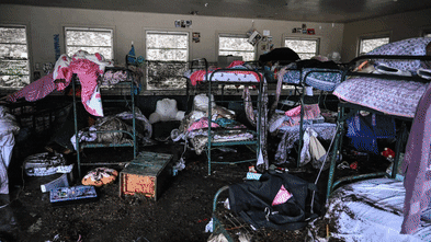


Destructive flash flooding in the United States has raised alarms about the effectiveness of the Federal Emergency Management Agency’s (FEMA) flood maps. On July 4, 2025, a severe flash flood devastated the childhood home of Nancy Callery in Hunt, Texas, underscoring the dangers of relying on outdated flood risk assessments.
FEMA’s flood maps, known as Flood Insurance Rate Maps (FIRMs), serve as the primary tool for identifying flood risks across the nation. Developed in the 1970s to support the National Flood Insurance Program, these maps inform local building codes and land-use decisions, while also guiding floodplain management strategies. In theory, they help homeowners and local officials prepare for potential flooding. Yet, recent events reveal that these maps often fail to account for the increasingly volatile nature of climate change.
During the flash flood that struck Kerrville, Texas, on the same day as the incident in Hunt, the Guadalupe River rose more than 30 feet. This dramatic rise highlights a critical flaw in FEMA’s mapping process: the current maps do not adequately capture the risks posed by flash flooding, particularly from smaller waterways like streams and creeks. This inadequacy is particularly concerning as climate change leads to more frequent and intense rainfall, putting additional areas at risk of flooding that remain unaddressed by FEMA.
According to research conducted by First Street, a non-profit organization focused on quantifying climate risk, more than double the number of properties nationwide are at risk of a 100-year flood compared to what FEMA’s maps indicate. The study utilized newly modeled flood zones, incorporating climate-adjusted precipitation records. This data reveals that even in mapped areas like Camp Mystic in Kerr County, Texas, the flood risk may be underestimated due to a reliance on historical data.
Political pressures further complicate FEMA’s mapping process. Local governments and developers may resist high-risk designations to avoid stricter insurance mandates or development restrictions. This political influence can lead to significant delays in updating maps and may result in communities being unaware of their true flood exposure. For instance, New York City has faced a prolonged appeal regarding a 2015 update to its FEMA flood maps, leaving it with maps that are nearly two decades old.
The time required to develop and implement new FEMA FIRMs can extend from five to seven years. Consequently, many flood maps across the United States are outdated, failing to reflect current land use, urban development, or evolving flood risks from extreme weather. This lag directly affects building codes and infrastructure planning, which rely on these maps for construction standards and flood mitigation projects.
Advancements in technology offer potential solutions to enhance the accuracy of flood mapping. Innovations such as satellite imaging, rainfall modeling, and high-resolution lidar can produce faster and more precise flood assessments that account for extreme rainfall and flash flooding. However, these improvements require substantial federal investment. Congress regulates FEMA’s mapping budget and the legal framework for map creation, making it a challenging issue for elected officials, who often hesitate to address the complexities associated with new flood designations.
In recent years, the rise of climate risk analytics and private flood risk data has enabled the real estate, finance, and insurance sectors to move beyond reliance on FEMA’s maps. Real estate platforms such as Zillow and Redfin now offer property-level flood risk scores that consider both historical flooding data and future climate projections. This shift is beginning to influence property-buying decisions, as consumers become more aware of flood risks.
As awareness of flood risks increases, the desirability of certain locations may shift, affecting property values, community tax revenues, and migration patterns. While this change may appear driven by new data, the underlying risk has always existed. The key difference now is that individuals are more informed about these risks.
The federal government plays a crucial role in ensuring that accurate and up-to-date risk assessments are available to communities across the nation. As new tools and models for assessing flood risk continue to evolve, it is imperative that FEMA updates its flood maps to reflect the realities of a changing climate. The need for accurate flood risk information is more pressing than ever to protect communities and homeowners from the devastating impacts of flash floods and other extreme weather events.